Updates to outdoors Southern Nevada information include trails, websites
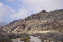
Entering a web address can mean experiencing more than 400 miles of trails and 316,000 acres of pristine meadows and forest just outside the computer screen.
Two initiatives to foster physical activity and utilize Southern Nevada outdoor potential launched recently.
Neon to Nature
Play gets plugged in with the city of North Las Vegas, the Southern Nevada Health District and the other local municipalities’ regional urban and nature trail system resource neontonature.org.
The website launched this year for Southern Nevadans to access maps, descriptions, lengths and available amenities for the estimated 460 miles of urban off-street trails and on-street bicycle lanes. More than 1,100 additional miles of recreational trails are in the works, including portions to link North Las Vegas trails, said city of North Las Vegas principal planner Johanna Murphy.
The Southern Nevada Health District launched Neon to Nature to centralize outdoor information and promote healthy living. Clark County, Henderson, the cities of Las Vegas and North Las Vegas and the federal entities contribute to the website.
Trail hours and rules vary. North Las Vegas trails prohibit equestrians, while some Centennial Hill trails encourage horse riding.
Murphy said North Las Vegas is building its trail system in segments, and residents have been confused about trail availability in the past.
"Our two traditional trails are the Las Vegas Wash Trail and the Upper Las Vegas Wash Trail in addition to park loop trails," she said. "We’re constantly adding new parts to the trails. People may not have realized that construction has completed (on a project), and they have a trail close to their home."
A pedestrian bridge over railroads and Interstate 15 to connect trails and a separate project on 15 new miles along the southern portion of the Las Vegas Wash trail are expected to be completed in late 2013.
The Las Vegas Wash Regional Trail System, which totals about 9 miles, is located primarily off-street, but in a few instances is aligned adjacent to roadways.
The trail consists of a 10-inch-wide asphalt multiuse path, meaning it is set to accommodate a variety of users such as walkers, joggers, cyclists, skateboarders, strollers, wheelchairs and other non-motorized transport, Murphy said.
Trail amenities include landscaping, lighting, trash cans, benches, dog waste stations, trail nodes with shaded rest areas and trail heads with shaded picnic areas, drinking fountains and off-street parking.
"By the end of 2013, people will be able to walk and hike from Tropical Parkway and Valley Drive to our southern border at Lake Mead Boulevard and Owens Avenue," Murphy said. "It’s a great way to out there and get some exercise, explore trails and take family outings. We hope it’ll stick."
For more information, visit neontonature.org or call 759-1270 .
Go mountain, go
Gomtcharleston.org is the result of an identity crisis turned opportunity.
Project partners the U.S. Forest Service, Spring Mountain Conservancy and the Great Basin Institute have decided to rebrand their online resource discoverspring mountains.org and encourage visitors to "Go Mount Charleston."
The bugs to gomtcharleston.com are still being worked out, but officials say the new website will be more user-friendly and interactive as visitors seek information about hiking, camping, construction updates and more.
The area in question is the Humboldt-Toiyabe National Forest in the Spring Mountains National Recreation Area. To the layman, it’s Mount Charleston, said Spring Mountain Conservancy spokeswoman Suzanne Hicks .
"Mount Charleston is really the name of the town," she said. "We didn’t want to lose sight of what the area is really called. It’s a name people identify with more."
The site’s name change comes before an era of construction. Several projects to upgrade campgrounds, trailheads, roads and a visitor center are expected through 2014. The website is to include current information for those curious about project statuses or restrictions, Hicks said.
"Construction is never set in stone, and deadlines and timelines do change," she said. "The website will reflect that."
Interactive tools will help visitors find and register for the free hikes and programs, such as kids’ Science Safaris, Hicks said.
The previous web address is to reroute to the new site.
"We want to continue to offer great new programs and build a respect and stewardship of this area," Hicks said. "This is public land that belongs to everyone."
For up-to-date construction information, call 515-5447 or visit fs.usda.gov/htnf/smnra_construction.
For U.S. Forest Service only information, visit fs.usda.gov/htnf.
For more information on the site changes, visit gomtcharleston.com.
Contact Centennial and North Las Vegas View reporter Maggie Lillis at mlillis@viewnews.com or 477-3839.