Messaging systems to help drivers avoid gridlock
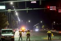
A few days back, I hopped onto U.S. Highway 95 in downtown Las Vegas, and right away, my cruise came to a crawl. A jackknifed truck stopped northbound traffic cold during the afternoon rush.
It took me 45 minutes just to exit U.S. 95, work my way around the wreck and get back on the freeway two interchanges down the road. Wish somebody would have told me about the mess before I hit the highway.
Maybe in the future, we’ll all be so lucky. Soon, Las Vegas Valley drivers will be getting such a heads-up and some help in detouring around driving disasters.
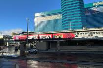
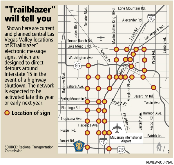
Offering the helping hand will be an electronic sign network called "Trailblazer," one of a number of messaging systems slated for roll-outs in late 2007 or early 2008 aimed at giving drivers up-to-date traffic information so they can avoid trouble spots instead of getting stuck.
"We want to provide real-time traffic data that will be meaningful to people," Jacob Snow, general manager of the Regional Transportation Commission, said last week. "The better information and the more timely information we can get to the public, the more people we can cause to be alleviated from some significant traffic frustration and loss of time.
"It’s just one important tool that’ll help people avoid being stuck in traffic," Snow said.
A total of 117 Trailblazer signs are being installed at 39 intersections of major streets feeding traffic to, along or around Interstate 15, including Las Vegas Boulevard, Martin Luther King Boulevard, Eastern Avenue, Decatur Boulevard, Valley View Boulevard and Charleston Boulevard, among other streets.
Another 19 message boards are also being placed at eight I-15 interchanges in the central Las Vegas Valley.
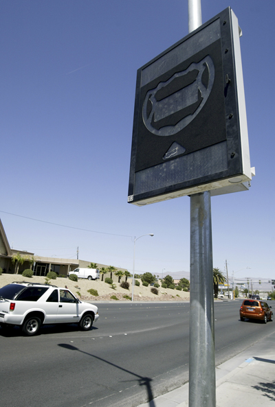
The signs consist of a vertical electronic message board with a highway shield shape in the center. When the shield is illuminated, it means there is a major problem on the freeway. Also illuminated with be an arrow pointing drivers toward a detour.
"When there is a major closure on the freeway — and we’ve certainly had our share of those over the years — it is a way to route traffic and allow the traffic to find where they need to go to get around the congestion and onto the freeway," Snow said.
"It’ll have the direction you need to go to get on the freeway" past the stricken stretch of road, Snow said. "Those signs aren’t going to go on unless we know there’s a closure of the freeway."
Such instances could include a less-than-total closure of highways that are significantly jamming traffic. Snow said it’s up to freeway engineers and the Nevada Highway Patrol to develop a formal activation policy before the signs come to life.
Eventually, plans call for installing Trailblazer signs on many major streets feeding other stretches of I-15 as well as U.S. 95 and the Las Vegas Beltway.
Meanwhile, the Nevada Department of Transportation, working in conjunction with the Transportation Commission, is moving toward further use of what engineers like to call "Intelligent Transportation Systems," or ITS, in the valley.
One such application will finally utilize those over-the-road electronic message boards on I-15 and U.S. 95 now used for posting the occasional kidnapping "Amber Alert" and warnings about only the most serious roadway shutdowns.
The state is contracting with a private company to install radar along the valley’s freeway network with the intent of gauging traffic speeds and relaying that information to commuters, cops, engineers and traffic reporters via the Internet, e-mail, cell phones, in-car navigation devices and whatever the flavor-of-the-month is in personal communication devices.
How does that involve the message boards? Snow said the boards will probably use that data to post real-time point-to-point travel times, based on traffic speeds being noted at that precise time.
So a board on Summerlin Parkway feeding U.S. 95 could have a message such as: "Rainbow Curve to Spaghetti Bowl: 12 minutes," allowing a driver to judge whether the time is reasonable or whether they should exit the highway and seek a quicker detour.
Speed sensors can also allow drivers and others getting that data to more quickly discover wrecks and judge the impact to traffic. Seeing a travel time inflate or an average speed of travel plummet would be a clue that there’s something amiss on the road ahead that needs to be checked or avoided.
Likewise, a commuter who hears of a highway wreck but then finds that travel times and traffic speeds seem normal can surmise that the wreck has been moved off to the side or towed away and that no detour is necessary.
That’s seriously lacking from today’s traffic reports, which rely heavily on police calls of crashes but often fail to note whether the wreck is actually slowing traffic. Likewise, such reports often miss slowdowns not involving a call for assistance.
For those who can’t wait for tomorrow for sneak peeks at traffic, the valley does have a smattering of highway cameras in a dozen or so locations, mostly along I-15 and U.S. 95. You can take a gander online at www.nvfast.org/trafficcameras.html.
You’d be forgiven if you think there are more cameras than there actually are (most devices atop light poles and stoplights in the valley are actually sensors and not cameras). But engineers hope to expand the camera network in the coming years.
In the meantime, if there’s a wreck, you’ll have to blaze your own trail for a bit longer.
If you have a question, tip or tirade, call the Road Warrior at 387-2904, or e-mail him at roadwarrior@reviewjournal.com or OSofradzija@reviewjournal.com. Please include your phone number.
ROAD WARRIORMORE COLUMNSDiscuss this column in the eForums!Drivers on U.S. Highway 93 near the Hoover Dam can expect alternating one-way traffic at night or other traffic restrictions during the day to allow work on the dam bypass bridge. Drivers should use extreme caution and follow all traffic controls. The Nevada Department of Transportation is holding a public information meeting regarding the proposed widening of Lake Mead Parkway (state Route 564) at Lake Las Vegas Parkway in Henderson from four lanes to six lanes, and making traffic- movement improvements at that intersection. The meeting is from 4 to 7 p.m. Tuesday at Henderson City Hall, 240 Water St. Comments will be accepted at the meeting or in writing before 5 p.m. May 11. Comments can be sent by postal mail to Daryl N. James, P.E., Chief, Environmental Division, Nevada Department of Transportation, 1263 S. Stewart St., Carson City, NV 89712, or by e-mail to info@dot.state.nv.us with a reference to the project in the subject line. Drivers can expect lane restrictions on northbound and southbound Interstate 15 between the California-Nevada state line and the Cajon Pass near Devore, Calif., in San Bernardino County, Calif. Drivers should expect delays and watch for updates on specific closures. To sign up for e-mail alerts on I-15 road work in California or for more project information, go online to www.caltrans8.info. For phone updates on Southern California road work, call (916) 445-7623 or (909) 383-7960.