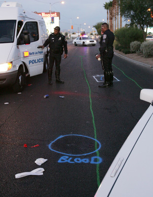
Colors record wreck marks

This week, readers want to know when green means dead, and if there’s any streetside snooping going on in the valley.
And the Road Warrior finds science at work at the DMV.
Steve Detrick asks: I’ve noticed that at some accident sites there are green lines where the accident occurred. Later, reading about the accidents in the Review-Journal where death has resulted, it dawned on me that the green lines are put down when a death has occurred. Is that accurate?
You’re onto something, Steve.
Police accident reconstructionists use water-soluble paints to record where vehicles collided and came to rest, along with the path of skid marks and where bodies were found, according to Sgt. Tracy McDonald, who heads the fatal crash investigation detail for Las Vegas police.
"There’s a couple of reasons we do that," McDonald said. "When we go to photograph the scene, we’re able to pick up the skid marks more clearly" when highlighted by painted stripes.
And if authorities should make a mistake when first investigating a wreck, police can go back and recheck markings and make any necessary revisions, he said.
Police use up to eight different colors to denote vehicles, people, skid marks, and incident starting and ending points, McDonald said. What color represents what depends on the officer.
"It’s the investigator’s choice," McDonald said. "Sometimes, we match the color to the vehicle" and its color.
The paint eventually fades, but could linger anywhere from two weeks to six months, McDonald said.
The reason Steve sees the painted areas where death has occurred is because in most cases, investigators will recreate a crash scene only if the wreck involves life-threatening injuries or a death, according to McDonald.
Sharlene Walker asks: At almost every intersection throughout the valley, there appears to be cameras mounted on the street lights. Are all of these cameras activated? I know currently there are discussions going on about using them for traffic offenders, but for what reason were they initially installed?
In virtually all cases, what you see is not what you get.
Most valley intersections are equipped with what appear to be cameras, but most often the devices are actually sensors that track traffic flow and movement, without any images being taken or watched.
The sensors are used to help keep track of traffic flow or, in some cases, to allow stoplights to set patterns based on the traffic conditions the sensors are noting.
Cameras are located in fewer than a dozen locations, mostly along the valley’s freeway network. Those cameras are monitored by the Freeway and Arterial System of Transportation, known as FAST, which is a Regional Transportation Commission subagency responsible for traffic management in the Las Vegas Valley.
Current camera locations include Interstate 15 at the southern Las Vegas Beltway; between Flamingo Road and Tropicana Avenue; at Charleston Boulevard; at the U.S. Highway 95 "Spaghetti Bowl" junction; and at Lake Mead Boulevard in North Las Vegas.
Las Vegas Boulevard camera locations include intersections with Flamingo; Convention Center Boulevard; Charleston Boulevard and Lake Mead.
And a U.S. 95 camera is located near Bruce Street.
Commuters can watch real-time camera images online at http://www.nvfast.org/trafficcameras.html. FAST hopes to expand on the network in the coming years.
Hit ‘n’ Run: Road Warrior unindicted conconspirator Susan McCune can remember stuff she learned in high school (whereas I forgot stuff as soon as it entered my noggin). She proved it recently at the corner of Sunset Road and Green Valley Parkway.
"I saw a silver Honda Element with the following license plate: HIHO AG," she said.
"I thank my high school chemistry teacher and many Saturday mornings watching ‘The Lone Ranger’ for the chuckle I enjoyed," she said.
If you haven’t figured it out, I ain’t tellin’. Ask the nearest geek or consult a periodic table.
If you have a question, tip or tirade, call the City Desk at 383-0264, or send an e-mail to roadwarrior@reviewjournal.com. Please include your phone number.
ROAD WARRIORMORE COLUMNSDiscuss this column in the eForums!Today and Thursday, drivers can expect lane reductions on northbound and southbound Nellis Boulevard between Charleston Boulevard and Stewart Avenue to allow underground sewer work. Then, Thursday and Friday drivers can expect lane reductions on northbound Nellis Boulevard between Cedar Avenue and Bonanza Road to allow further underground sewer work. And on Friday and Saturday, drivers can expect lane reductions on northbound Nellis Boulevard north of Bonanza Road to allow more underground sewer work. Drivers can expect lane reductions into November on Valley View Boulevard, between Alta Drive and U.S. Highway 95, to allow road work. Delays can be expected. Authorities suggest using Decatur Boulevard or Rancho Drive as alternate routes.


