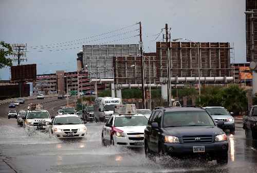
Summer dissolves in a splash

Yes, it rained Tuesday. And yes, lots of people went nuts. The traffic, the hyperbolic TV news reports, the few people who decided it would be a good idea to drive through floodwater.
But something else went unnoticed.
Tuesday could be seen — nay, should be seen — as the unofficial end to summer.
There is evidence.
Exhibit One is 6 a.m. in mid-September, when the sun is rising and there is a cool breeze coming in off the mountains.
It feels so good to be outside, not sweating, that it is possible to forget that the high temperature this past Friday was 100 degrees.
And that is Exhibit Two: Data.
The National Weather Service is a virtual warehouse of electronic data. Coldest temperature ever in July, most days in a row over 110 degrees, hottest month ever. Whatever you want, they’ve got it.
In an average year, using all of that data, the weather service says we usually hit 100 degrees or more seven times in September.
Guess how many times we’ve hit 100 degrees this month, including Friday?
Seven. We’ve met the statistical quota, hallelujah.
There is more.
It’s been a really nice year, overall. August was an aberration, the "which of these things is not like the other" month in a children’s game.
Spring was mild, temperature-wise. The first half of the summer was almost as mild, especially compared with the misery the rest of the nation had to endure. A high pressure system that usually sits in the Southwest instead parked itself over Texas, setting record highs there and throughout the Midwest.
Weather service meteorologist John Adair in Las Vegas says it’s all connected. Everything that happens over there affects what happens over here.
What that nasty weather back East did here was keep things nice. We never got over 111 degrees though June and July.
But then the high pressure system moved east, and August roared in. It was the hottest August ever here. It hit 112 degrees on Aug. 24, the hottest day of the year. Thirty of the 31 days in the month hit at least 100 degrees.
The heat wave kept going into the first few days of September, paused for a Labor Day break, then came back.
Until we hit that magic number seven, and then a low pressure system moved in and settled off the Southern California coast. It brought us the gift of Tuesday’s rain, with the hyperbole and the bad driving.
"These things create particularly interesting weather," Adair said.
He said there were no reports of serious damage from the thunderstorms throughout the valley. Rain was heavy at times in Henderson and in northeast Las Vegas, with some flooding on the roads.
A separate storm cell rolled through the west side of town overnight, causing some lightning strikes.
At least one car got stuck in water, and firefighters responded to lightning-related calls. Las Vegas Fire Department spokesman Tim Szymanski said that the department dealt with about 20 tree fires and that a power pole was struck by lightning.
So, the evidence is in. Summer appears to be over, despite the astronomical calendar that says we still have more than a week until the start of fall.
Adair says the forecast for the next few days is nearly perfect, with highs in the lower 90s and a chance of some more rain. It’ll warm up just a tad over the weekend, with highs in the mid-90s.
"It’s possible we could still sneak up above 100 in September," he warns. "But right now, it’s not looking like that’s going to happen."
Yes, with the weather, anything is possible. The analysis of it is not a perfect system. The evidence is not incontrovertible.
For example, the data show that the record high temperature for every single day in September is over 100 degrees.
And, perhaps most troubling, it has hit 100 at least twice in October.
Review-Journal reporter Mike Blasky contributed to this story. Contact reporter Richard Lake at rlake@reviewjournal.com or 702-383-0307.


