Gypsum Ridge development might evolve into gateway


A rocky ridge towering above homes on the southwest edge of Summerlin looks inhospitable from the street.
But in the not-too-distant future, traversing this ridge could be as easy as strolling through the neighborhood.
A proposed 1.2-mile trail that would stretch across the side of Gypsum Ridge would offer a scenic walk to almost anyone, including people with disabilities. And it would act as a launching point for hikers seeking a more adventurous route — whether it’s plowing up the slope or trekking seven miles to Blue Diamond detention basin.
The trail would be a gateway to the 1,200 acres of Clark County land wedged between Red Rock Canyon, Mesa Park and Summerlin.
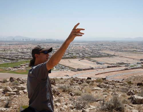
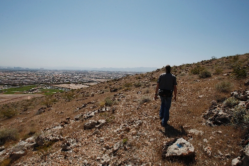
"You have to have something to get people into the area, then you can explore the area," said county parks planner Justin Williams, his shoes crunching on loose rocks as he walked along the ridge where the path would be built.
Williams strode to a strip of level terrain along the hillside. He said it’s perfect for creating a user-friendly trail that’s not too steep.
Longer-range plans call for carving out more trails, including one to the hilltop and one extending into the southern portion of Gypsum Ridge, Williams said.
Some hikers and motocross riders already travel across the rugged terrain deep into the county’s land, according to a study on Gypsum Ridge.
Creating a real path would make the area safer and more accessible to everyone, Williams said.
PAYING FOR IT
To cover trail construction, county officials have applied for about $1 million from the U.S. Bureau of Land Management’s regional property sales.
The county also aims to spend another $1 million to build a small park at the trail head that would have a picnic area, restroom and an eventual parking area. Officials would tap a county fund fed by home construction fees, which can be used only to develop parks.
BLM dispenses money each year to local governments in Nevada to upgrade recreation. An executive committee ranked the Gypsum Ridge trail fifth among 10 projects on a priority list, county park officials said.
The panel will make recommendations in mid-June to the U.S. Department of the Interior about which projects should be funded this round. Agency heads are expected to choose the projects by October.
Being midway on the priority list doesn’t put Gypsum Ridge out of the running, but it does hurt its chances given the federal government’s current budget climate, said Wendy Fenner, a county civil engineer who helps administer the BLM grants.
BLM funding for parks has waned in the bad economy, with fewer projects being granted fewer dollars, Fenner said.
"It’s been drying up," she said.
One advantage in the depressed market is that contractors are charging less for work, reducing a project’s cost, Fenner said. So, if the feds award money to Gypsum Ridge, it will go further than it would have several years ago.
If Gypsum Ridge is rejected, the county will have to wait until next year for another shot at the funding, she said.
Williams said the county could explore other funding options, though he didn’t know what those would be.
"We’ll have to go back to the drawing board," he said.
HISTORY AND FUTURE
Congress transferred the Gypsum Ridge land to the county in 2002, and plans to develop a trail there have been in the works for several years.
The ridge juts 3,400 feet above sea level. From the top, you enjoy a far-flung view in all directions.
On the horizon to the east is the Strip’s haze-engulfed cityscape. To the west is the massive Blue Diamond Hill, where developer Jim Rhodes wants to build high-end homes overlooking the valley.
To the southwest are Red Rock’s mesas, marbled in reddish brown and ochre. Below are countless rooftops that, from this height, meld into a brown mosaic. Earth movers tidying up dirt lots for new homes near the base of the ridge foretell the housing market rebound and serve as a reminder that the trail’s first leg will be urban.
The county land is split into two chunks, with some hilly BLM land sandwiched between them. The proposed 1.2-mile trail would be on the northern portion.
The trail eventually would extend another six miles south, crossing the BLM land and ending at Blue Diamond detention basin. If maintained, this longer trail would be suitable for mountain bikers, according to a county report.
Williams, who has hiked the entire seven miles, described the trek as good workout with diverse scenery.
A gypsum mine that once operated on the southern section had a rail line to haul out raw materials. The mine shut down decades ago, and the tracks were torn out.
Bootleg Canyon Flightlines approached the county about setting up a zip line on the southern tract. The company runs zip lines in Boulder City and Fremont Street.
Williams said a zip line would be fun to consider in the future, but for now the county must focus on building the trail on the northern property.
There has been talk of linking Gypsum Ridge’s trail with Red Rock, but no one has explained how it would be done, Williams said.
Some local groups and agencies have discussed creating a trail encircling the valley and connecting various trail systems, including Gypsum Ridge, Red Rock, Nellis Dunes, Lake Mead and River Mountain Loops Trail. In fact, the River Mountains Trail Partnership Advisory Council took suggestions until Friday on what to name the hypothetical trail.
Fenner predicted it will take a long time before something of that scope materializes.
Commissioner Susan Brager, whose district encompasses Gypsum Ridge, said she encouraged the county to pursue BLM funding for the walking path.
She agreed it was a good starting point for the site.
People need more recreational choices, Brager said, adding that she would like to see hiking trails built there.
"It would be over-the-top fantastic," she said.
Contact reporter Scott Wyland at swyland@review journal.com or 702-455-4519.


