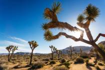
The lonely washboard of Racetrack Road awaits
Most people aren’t aware that Death Valley National Park boasts about 1,000 miles of paved and gravel roads, more than any of our nation’s parks. One road in particular, the unpaved, 27-mile Racetrack Road, offers one of the finest day outings in the park.
The highlight of the road is to see the Racetrack itself, a playa or dry lake bed, where rocks seem to have moved on their own, without any discernible help from human or natural forces, leaving deep and obvious tracks. But even before you reach this highlight, you’ll get to see two other famous sights – the impressive Ubehebe Crater and fanciful Teakettle Junction.
Ubehebe is a maar volcano, meaning it was formed when molten rock contacted ground water, creating a major explosion of steam and gas. Although some estimates place that event 3,000 years ago, the resulting crater remains a half-mile across and 600 feet deep. Its shape is reflected in its name; "Ubehebe" is a Paiute word that means "basket." If you have the time, it’s fun to hike the 1½-mile trail that skirts the rim. Or you can head directly down into the crater. The latter isn’t a dangerous hike, but it is a strenuous one for the short distance; once you’ve reached bottom, it’s a steep climb back to the rim.
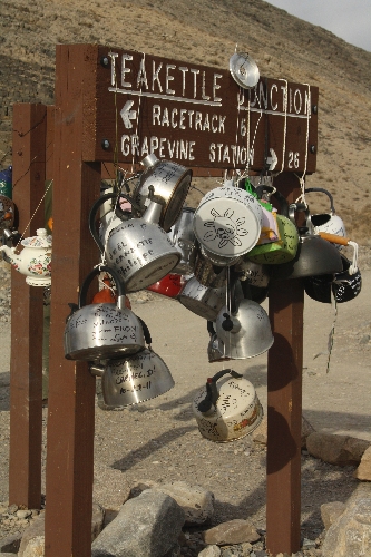
The road is paved as far as Ubehebe, but from that point on, Racetrack Road is a brain-rattling washboard track on the valley floor, heading south between the Cottonwood and Last Chance mountain ranges. After about 20 miles, you will arrive at Teakettle Junction. The wooden sign is usually covered with teakettles left by visitors. Most are decorated or have messages on them such as names and dates. Each time I have visited, there are different teakettles, so I suspect the park service removes them every so often.
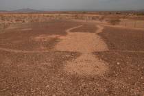
After Teakettle Junction, continue south for about seven miles, and you will be at the north end of the Racetrack Playa. At the first parking area, look out across the playa at the enormous pile of quartz monzonite boulders, which is called the Grandstand.
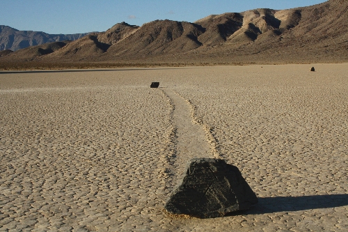
From there, continue on the road south for about two more miles to the second parking area. Walk out on the playa about a half-mile, and you will find dozens of rocks and small boulders scattered on the playa. From these rocks, some more than 2 feet tall, you will see clear trails in the playa where the rocks have moved. It is quite a mysterious thing to see, and many theories abound as to how it happens.
The most popular theory is when the playa receives high winds – 50 mph or more – and lots of rain, the rocks move across the slippery mud, leaving the deep grooves, some hundreds of feet in length.
Do not drive onto the playa at any time and don’t even walk on it if it is muddy or damp. Tire tracks or footprints can last for years and ruin the natural and stunning landscape. It’s usually dry enough to walk, but verifying that is one more good reason to visit the park visitor center at Furnace Creek on your way there. If wet weather is in the recent past or near future, why not go somewhere else in the park that day and postpone your Racetrack visit?
Preparation is even more important for this trip than for most. You must have a high-clearance vehicle, preferably four-wheel-drive, with excellent off-road tires, a good, well-inflated spare, and the jack and lug wrench to change a flat. If you own a second spare, bring it; I’ve seen vehicles with two flats on this road. The trip takes a full day if all goes well, but in case it doesn’t, carrying several days’ worth of water, food, blankets and warm jackets for the cold nights could make the difference in an unexpected but tolerable delay and a life-threatening survival experience. Cellphones do not work in this area, and you can’t count on anyone else being on the road the same day should you need help.
If you’re well prepared and drive safely, though, the loneliness of Racetrack Road should not cause you anxiety but pleasure.
Deborah Wall is the author of "Great Hikes, A Cerca Country Guide" and "Base Camp Las Vegas: Hiking the Southwestern States," published by Stephens Press. She can be reached at deborabus@aol.com.
DirectionsFrom the Furnace Creek Visitor Center, drive north on California state Route 190 for about 17 miles and go right onto Scotty’s Castle Road. Follow for about 33 miles and go left onto Ubehebe Crater Road for 5.7 miles to the crater. Continue south on the gravel Racetrack Road for about 27 miles to Racetrack Playa.