Rock Spring Loop still cool enough to enjoy
Before the weather gets any hotter in our region, a good place for a short hike might be Mojave National Preserve in California just south of the Nevada border. One you might try is the Rock Spring Loop, which boasts a historic stone house, the site of a 19th-century Army post, a natural spring and American Indian petroglyphs.
The trail offers an easy 1-mile hike with only 100 feet in elevation change. It starts at about 4,900 feet, a pleasant altitude in early summer, with temperatures likely to be about 10 or 15 degrees cooler than Las Vegas. Even so, I would get to the trailhead early in the morning to enjoy the hike at its most pleasant time.
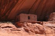
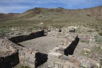
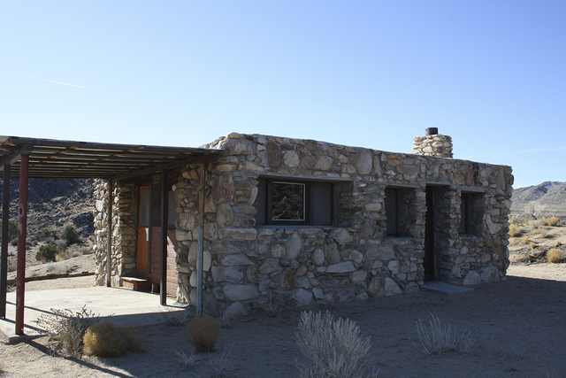
From the parking area, walk through the hikers’ gate, and just a few minutes later, you will be at the Rock House. The house was built in 1929 by homesteader Bert G. Smith, a World War I veteran whose lungs had been damaged by poison gas and who came to the desert hoping to prolong his life. It worked; Smith lived in his own home 25 more years and survived more than 30. Carl Faber, a noted artist, later lived in the house, as did a couple of other colorful folks.
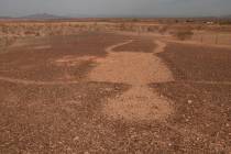
The loop trail starts from the west side of the house and first goes south, then heads down the hill to the east. As you walk along, you will soon see the wide sandy wash below, where the trail will continue. This area was the site of Camp Rock Spring from 1866 through early 1868. Camp Rock Spring was one of many U.S. Army posts established along the remote Mojave Road, in Arizona Territory and California, to ensure the safe delivery of U.S. mail and supply wagons. Living conditions were bad, and out of the 73 men stationed there during the post’s 15-month operation, 20 deserted.
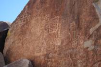
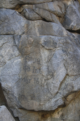
Once you arrive in the drainage, turn right and head upstream. On the north side of the wash, you will find many American Indian petroglyphs on the granite walls. On the south walls, you will find an interesting inscription left by a soldier. It reads: Stua, 4th Inf. May 16. I am told this was most likely written in 1863 or 1864 by Charles Stuart, a musician in Company B 4th Infantry, California Volunteers.
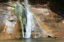
If you continue up the wash, you will come to Rock Spring, where even in the driest times I have found at least some water. There are some large boulders strewn around the spring, perfect for sitting and taking a break in the shade of the deciduous trees growing there.
Water was life in the desert, especially in the days before speedy travel by motor vehicle, so the spring was the very reason the trail passed there, and an army post was thought necessary. Later, it gave its name to the Rock Springs Land and Cattle Company, which ruled a million acres of grazing lands by controlling water sources. The cattle empire’s cowboys fought homesteaders and rustlers, with occasional gunplay. Eventually, the company broke up into several ranches, and cattle operations continued into about 2001.
After visiting the spring, head back down the wash, and you will pick up the continuation of the loop trail. This will lead you up and onto a natural bench where it then swings back to the northwest to a ridge. There you can see the Providence and Hackberry Mountains. The trail then heads back up and ends between the Rock House and the parking area.
Directions
From Las Vegas, take Interstate 15 south for about 50 miles. Exit onto Nipton Road and go east 4 miles. Turn right onto Ivanpah Road for 3 miles, and go right onto Morning Star Mine Road. Drive 18.4 miles through Cima and go left onto Cedar Canyon Road. (After about 2 miles, the paved road becomes gravel, but it’s well-maintained and suitable for all vehicles except during or after heavy rain.) Follow Cedar Canyon Road for 10.1 miles, and go right two-tenths of a mile to parking area and trailhead.
Deborah Wall is the author of “Great Hikes, A Cerca Country Guide” and “Base Camp Las Vegas: Hiking the Southwestern States,” published by Stephens Press. She can be reached at deborabus@aol.com.
Directions
From Las Vegas, it is about 285 miles to the trailhead. Take Interstate 15 north 125 miles into Utah and take the Hurricane/Zion National Park exit. Follow state Route 9 for 57 miles through Zion National Park, and turn left onto U.S. Highway 89 north. Take Utah state Route 89 for 44 miles to a right onto Utah state Route 12. Follow that for 60 miles to the town of Escalante. Drive east on state Route 12 for 5 more miles, then turn right onto the well-marked Hole-in-the-Rock Road. Follow this gravel road for about 26 miles, and go left on Dry Fork Road, staying left at the fork and follow about 1 ½ miles to trailhead.