Rings Loop Trail offers an experience that will stick in memory
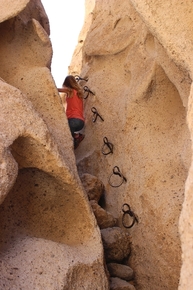
For an outdoor experience that’s different enough to make long-lasting memories, consider the Rings Loop Trail in the Mojave National Preserve, Calif. Located near the Hole-In-The-Wall campground, the trail is named for the metal rings bolted into the walls of a short, yet steep slot canyon. You will use these rings and bolts to help you climb up or down the slot.
While the trail is easy for the most part, the slot canyon is boulder-filled, and the slippery rings and bolts can be tricky to use, so I wouldn’t recommend this hike for those with very young children.
The elevation at the trailhead is about 4,265 feet, so expect temperatures to be about 10 degrees cooler than Las Vegas. Thus, the coming few weeks should offer tolerable temperatures to enjoy the preserve, green with new growth and spangled with the last of spring’s flowers.
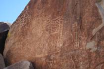
The Hole-in-the-Wall Information Center’s parking area serves as the trailhead. From there, follow the worn path southeast around the cliff area. After about one-quarter of a mile, keep an eye out on your right for some faint American Indian petroglyphs. Follow the trail as it loops around near Wild Horse Canyon Road and then heads north into Banshee Canyon.
Banshee Canyon is attention-grabbing, for its walls and unusual free-standing formations are riddled with holes and windows, from which eerie faces appear to be watching your every move.
Millions of years ago, there were massive volcanic eruptions there, and gas was trapped in the ash, forming cavities. Over time, wind and rain exposed and enlarged these cavities. In this season, you’ll have no trouble understanding the canyon’s name, for strong spring winds blowing over these cavities moan most mournfully, calling to mind the banshee’s howl of Irish legend.
To reach the Hole-in-the-Wall slot canyon, head to the back left of Banshee Canyon. After heading up some small boulders, the canyon narrows significantly, and you will be at the base of the first set of bolts and rings. This first set is the easiest, as over the years, people have added large rocks to aid in climbing.
All you need to do is reach up and grab the highest ring you can, pull yourself up and rest one foot on a rock or on the top of the bottom bolt. Continue to do this until you reach the top of the six. It’s just a few yards farther to the second set, which consists of five rings and bolts. The second set is a little trickier to climb because the rings are not placed as conveniently as the lower ones were.
Once above the second set of rings, you will need to do some easy rock scrambling, and then you will come up and out of the canyon at the alternate parking and picnic area.
At the parking area, if you head to the right, you will find a spur path that leads to a blue fence.
This gives a good viewpoint down into the top of a lovely box canyon. Once back at the parking area, follow the gravel road a few hundred feet, and you will come back to the information center and your vehicle.
Deborah Wall is the author of “Great Hikes, A Cerca Country Guide” and “Base Camp Las Vegas: Hiking the Southwestern States,” published by Stephens Press. She can be reached at deborabus@aol.com.


