Truckee’s ‘silvery rills’ are making comeback
The Colorado River is mightier. The Humboldt, Carson and Walker rivers are longer. The Amargosa River is stranger. But the Truckee River remains Nevada’s iconic stream.
The official state song idealizes its “silvery rills” and the river figures prominently in Nevada history. The Truckee’s water is vital to the Reno-Sparks area and smaller northwestern Nevada towns.
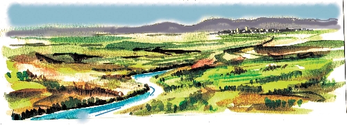
The Truckee River flows north out of Lake Tahoe from a dam near Tahoe City, Calif. It tumbles out of the Sierra Nevadas, cutting through stone to create gorges and whitewater rapids as it descends toward the quaint town of Truckee, Calif., near the infamous Donner Pass. Then it makes a sharp turn east into Nevada, coursing through scenic canyons to emerge into the Truckee Meadows, the valley where first Reno and later Sparks developed. It continues east around the end of a mountain range, then heads north again. It ends at Pyramid Lake, a little more than 100 miles from its origin.
The river’s course provided a transportation corridor for indigenous people paddling through its canyons. Mountainmen and explorers mapped the river, charting trails for emigrant trains headed for California. Roads were built along the Truckee as mining brought settlers to the Sierras. Railroads followed, coping with the area’s heavy winters by constructing miles of snow sheds over the tracks. Logging concerns built wooden flumes paralleling the river and using its own water to carry logs from the mountains down to mills in the valley. Nowadays, Interstate 80 follows the old transportation route along much of the Truckee’s length.
It has always been a busy little river and given to seasonal tantrums. Following a heavy, wet winter, the Truckee is sure to flood with devastating effects in the ever-expanding urban Reno-Sparks area. The cities welcome the river’s flow, which provides a large part of the area’s drinking water, but too much of a good thing has never been welcome. Therein lies the trouble with the Truckee.
Over the past 150 years, the Truckee River has endured construction of more than 30 dams and water supply diversion structures. It has been reconfigured, rechanneled and mismanaged until parts of it bear no resemblance to the original river. Industrial and commercial development supplanted scenery. Pollutants from industrial, municipal and agricultural sources fouled the water. In the 1960s, its bottom was dynamited and its channel straightened to allow floodwater to run away faster. The river lost most of its riparian habitat. The water table dropped. The fish, birds and wildlife dependent upon the river fled. But the Truckee still produced a terrible flood in downtown Reno one New Year’s Day.
Fortunately, the Truckee River is being treated much better these days. More people recognize the worth of the river to provide recreation for residents and visitors. Reno has regenerated part of the river with a popular water park with pools and whitewater for kayaking, tubing and body surfing. Miles of handsome riverside trails fan out along the Truckee through the urban area, inviting walkers, joggers and bicyclists. Fishermen find sport along the river. Families picnic there. Kids search in the shallows for crayfish and turtles. Riverside parks contain artwork, festivals and music that draw people downtown
For the past decade, The Nature Conservancy and a coalition of local, state and federal agencies, politicians, tribal groups, outdoors enthusiasts and volunteers labored to revitalize parcels of ranchlands on the lower Truckee east of Sparks. The public now has year-round, dawn-to-dusk access to the McCarran Ranch Project (www.nature.org/mccarran), which encompasses hundreds of acres, including nine miles of riverbanks. The coalition created a winding river with riffles and natural fish habitat. Wetlands and native vegetation fill flood plains, allowing floodwater to spread out. The water table is up. The birds and animals are returning. The “silvery rills” are back.
Travel Nevada’s favorite river to learn more about our diverse state. The Truckee River corridor along I-80 from mountains to sage flats offers some of Nevada’s best fall color. The season starts soon and lasts until the snow flies.
Margo Bartlett Pesek’s Trip of the Week column appears on Sundays.


