Valley soils amplify effects of temblors

Fine clay-rich sediments across much of the Las Vegas Valley have the potential to amplify ground motion from earthquakes and increase the seismic hazard, a team of university geologists said Friday.
When finished, the study by engineering professor Barbara Luke, her colleague Aly Said and geology professors Wanda Taylor and Cathy Snelson and students at the University of Nevada, Las Vegas will be used to create a three-dimensional seismic hazard map for emergency and land development planners.
"It provides the planners and policymakers with more information for disaster planning," Snelson said in an interview Friday.
A statement from UNLV quotes Luke as saying: "This is particularly important for Las Vegas because of our fast-growing population of residents and visitors, and because the more we learn about our earthquake hazard, the larger we find it to be."
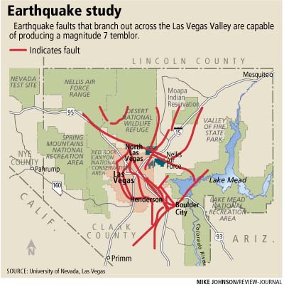
Faults that crisscross the valley and others in Southern Nevada and Death Valley have the potential to deliver earthquakes with magnitudes of 6.5 to 7. Amplified ground motion caused by fine, soft sediments at various locations in the Las Vegas basin makes the risk bigger than previously thought, Snelson said.
"I wouldn’t say it increases the seismic risk a lot," she said. "We knew it was pretty high (but) the potential of an earthquake is the same. We could have an earthquake today or in 10,000 years."
Taylor, who leads the Geoscience Department at UNLV, said the study that began about four years ago has produced "a lot of data. We’re doing the analysis to make sure we make the correct interpretation."
She said that although the study identifies areas where fine grain sediments are likely to amplify ground motion, "we don’t want to be alarmists."
The west side of the valley has the lowest ground-shaking hazard, Taylor said.
"The new information means that we have and will have better information to provide local policymakers and lawmakers about what (building) codes and emergency preparedness plans we need," Taylor said.
The study has been funded the past three years by grants totaling $3 million from the Department of Energy, the U.S. Geological Survey National Earthquake Hazards Reduction Program and the Nevada Earthquake Safety Council.
The roots of the study date back to 2003 when Snelson and other scientists placed a half-dozen ground-motion wave recorders, or seismographs, at strategic locations. The instruments were put in holes at schools and Nellis Air Force Base to record simulated shock waves from an earthquake of less than magnitude 2 that were caused by detonating up to 1,500 pounds of chemical explosives.
In addition to the six seismographs, another 825 portable seismic instruments were used in the $150,000 experiment.
This summer, Luke and a team of students intend to test soils at 40 places in the valley to complete the three-dimensional seismic hazard map. They will use a 7,000-pound portable seismic source, called a "minivib," to determine how energetic shock waves from an earthquake are amplified as they travel through soils in the valley.
Taylor said the study is being expanded to include the Pahrump area.