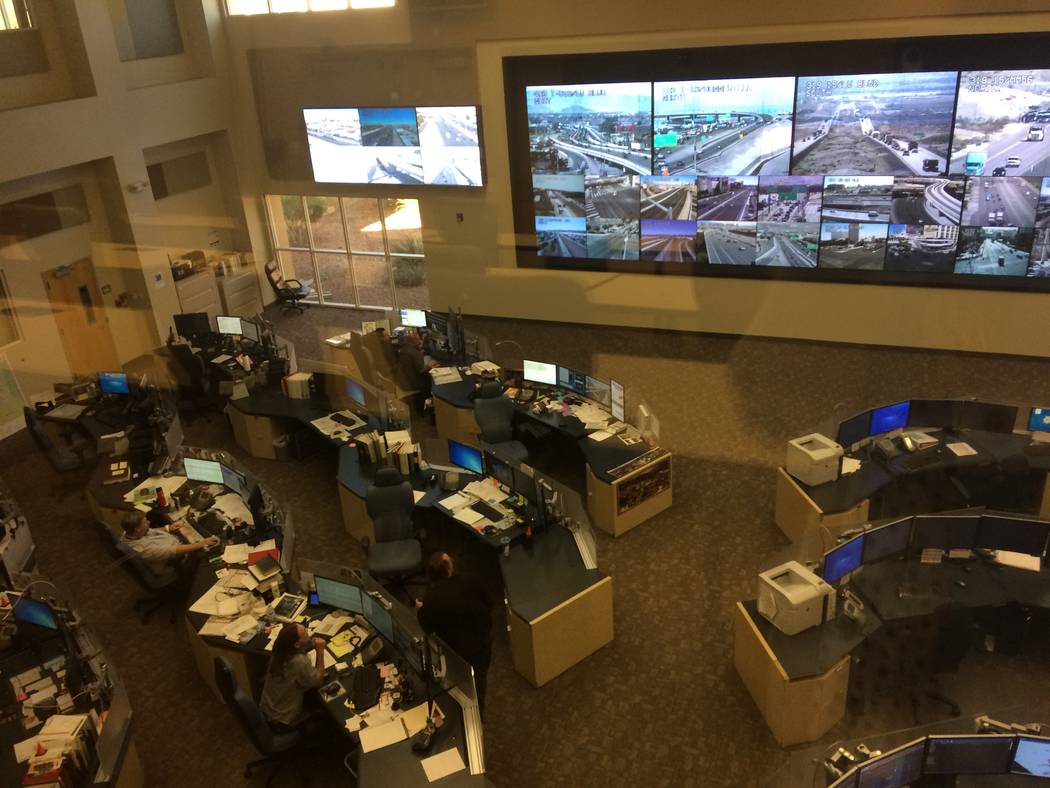
Eyes on the roads: RTC department monitors 600 Clark County traffic cameras

You roll up to a green light only to have it turn red, but there is no cross traffic. Still, you have to wait.
Ever wonder who decides that? The Regional Transportation Commission of Southern Nevada’s Freeway & Arterial System of Transportation regulates all 1,400 or so traffic signals in the Las Vegas Valley.
It’s all done with cameras — roughly 600 of them — as well as magnetic loops embedded in some roads to detect vehicles. Infrared technology is being installed by the city of Henderson and various software systems are used. Giant screens at FAST’s headquarters at 4615 W. Sunset Road show traffic in real time.
The busiest part of town is Interstate 15 between Flamingo Road and Tropicana Avenue, which sees an average of 300,000 vehicles on a Friday, the busiest day of the week, according to RTC and FAST. In comparison, Flamingo Road near Decatur Boulevard will see 70,000 that day of the week, said RTC and FAST.
“A doozie is Eastern and Sunset, partly because you have the airport (access nearby),” said Brian Hoeft, the director of FAST.
The main east-west travel routes are called majors. They see more traffic than north-south streets, so majors get preference for green lights.
Senior traffic technician Ken Hutchens has been directing traffic at FAST for 25 years.
“If I see any backup, I try to take care of that, depending on what (caused) it,” he said and pointed to his screen, showing a road grid covered in colored dots. “The yellows are slowing down, the reds are when they’re pretty much at a stop, the greens show (traffic) flowing smoothly. All these blue dots? Those are the cameras.”
The longest cycle of a traffic light — from yellow to yellow — is three minutes. Different cycles are run at various locations throughout the day, determined by traffic history.
Traffic cameras appeared on streets in the 1990s. In the early 2000s, they were added to freeways. They are all over the valley and extend down to Primm and up to Mesquite. Everyone is being watched, but not for Big Brother reasons.
“We’re zoomed in on some of these cameras to the max that we can zoom in,” said Shital Patal, manager of operations at FAST, as he pointed at the screens.
In other words, cameras do not zoom in to watch you put on makeup or check your phone at the red light. They do not record your license plate or note an emissions violation. Hoping there’s video of your accident? Sorry, FAST cameras don’t record.
In and around Summerlin, most areas are considered “trip generators”; they generate traffic when homeowners leave for work or to run errands. When drivers turn onto a major street — say, Charleston Boulevard — they eventually join a “platoon” of vehicles that travel as a pack. Lights are sequenced to ensure platoons keep moving. A street in Summerlin might see 5,000 to 8,000 vehicles a day. With so many four-way stops, there are few cameras in the suburbs save for the majors such as Sahara Avenue or a major north/south road such as Durango Drive.
“Once you get off the main grid and into a neighborhood, traffic can fend for itself,” Hoeft said.
Six FAST technicians watch the traffic flow in 10-hour, four-day shifts. The Nevada Department of Transportation takes over for the unstaffed hours at night.
Colored dots on technicians’ desk screens show how fast traffic is moving.
Traffic light cycles “can run from 100 seconds all the way up to 180 during the rushes. Once we get the corridor set, it stays the same for quite a long time,” Hutchens said.
When there’s an accident or a bottleneck due to roadwork, it’s their job to slow approaching traffic.
Ambulances and police can override a traffic light by turning on their light bars. The rapid flashing triggers a sensor that makes the light green for them. (Don’t try flashing your bright lights in rapid fashion; drivers cannot manually match the rapid signaling needed.) The traffic light then has to reset to get back into sequence, which can take more than five minutes.
There is no rule for how long green lights stay green. Left-turning vehicles are allotted perhaps 20 seconds.
When the power goes out, FAST is at NV Energy’s mercy. And when the U.S. president comes to town, “they don’t care about the lights; they just go through,” Hutchens said of the motorcade. “I mean, he’s the president.”
Waze, a free navigation app, partnered with FAST in April 2016. Kelley Waynert, public-affairs administrator with RTC, said it’s probably the most accurate way to map one’s route.
“It always gets me there the fastest way,” she said. “When the president was in town, I used it to get home and I got there in the same amount of time. My co-worker didn’t, and it took him an hour to get home. It takes you kind of weird ways, but it’ll work.”
To reach Summerlin Area View reporter Jan Hogan, email jhogan@viewnews.com or call 702-387-2949.