The Lure of Somewhere Else
The Utah Loop
Forget overcrowded Zion — this beauty tour will show off the best of the Beehive State
By Greg Thilmont
Hello, road trip season! Spring is here, and many of us have Southern Utah adventures on our minds. There’s a bit of a problem, though: Mainstays like Zion National Park and Arches National Park are thronged with visitors.Thankfully, there’s an alternative: a loop stretching from Bryce Canyon National Park to Goblin Valley State Park and back. This 375-mile route is filled with soaring sandstone cliffs, dense pine forests, and twisting desert canyons. Fascinating cultural sights abound. 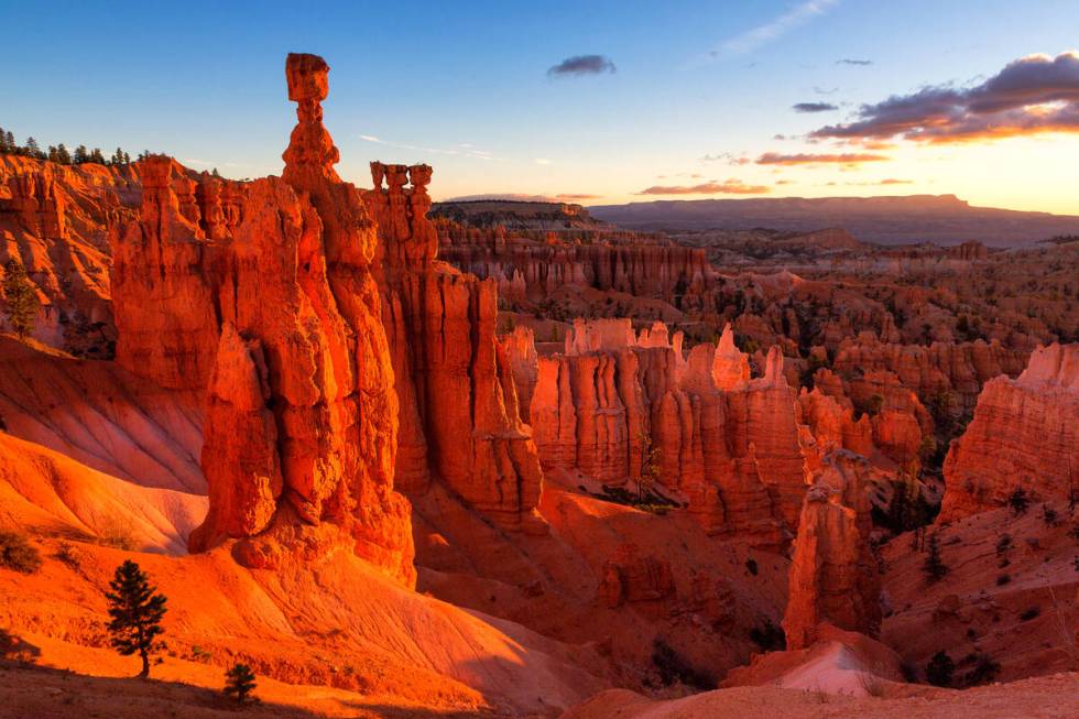
Explore Escalante country: Starting from the ruddy fairyland landscape of Bryce Canyon, head east on state Route 12 as it dips into rugged Escalante country, most of which is part of the 1.87 million-acre Grand Staircase-Escalante National Monument. Tiny towns founded by the 19th century Mormons line the asphalt: Tropic, Cannonville, Henrieville and Escalante, each with their unique charms.
This segment of the loop features two divergent state parks: vertical Kodachrome Basin, with its 67 skyscraperlike stone spires, and horizontal Escalante Petrified Forest and its fields of fossilized trees. If the weather is dry, venture southeast on gravelly Hole-in-the-Rock Road to Devil’s Garden Outstanding Natural Area to meander under the distinctive Metate Arch. This remote area is a favorite off-grid camping place for me and my hiking buddies because of its numerous slot canyons with evocative place names like Peek-a-Boo, Spooky and Zebra.
Up and over Boulder mountain: Past Escalante to the next hamlet, Boulder, the highway courses over an undulating swath of nearly uninterrupted sandstone for some 20 miles — chances are you’ve seen the eye-popping road in car ads. This stretch of the loop is for walking, too, as it’s the entrance to Lower Calf Creek Falls: the 126-foot-high cascade is a gorgeous payoff just 3 miles from the trailhead.
After arriving in tiny Boulder, visit Anasazi State Park. Built around the ruins of a sizable ancestral Puebloan village dated from roughly A.D. 1050 to 1200, the preserve boasts excavated ruins; a life-size, six-room replica of a once-bustling pueblo; and an interactive museum.
From Boulder, Route 12 ascends along the verdant flanks of 11,317-foot-tall Boulder Mountain, part of the immense Aquarius Plateau. Covered with foliage, it’s a stark contrast to the sere lands around it, including the 100-mile-long Waterpocket Fold, a warped and scalloped strip of sedimentary rock that can be seen to the east, as well as the remote, pyramidal Henry Mountains, the last range to be mapped in the Lower 48. 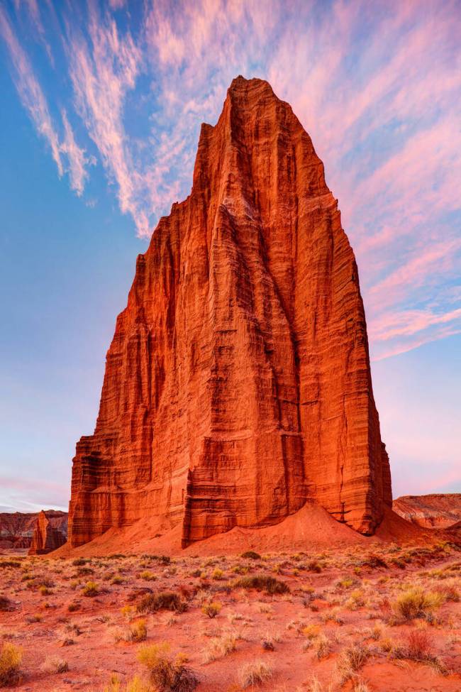
A breathtaking natural bonus: Descending from Boulder Mountain, head east on state Route 24 to reach one of the highlights of this expedition: Capitol Reef National Park. Never heard of it? You’re not the only one. Equal in beauty to its more famous cousins, the park drew fewer than 1 million visitors in 2020, as opposed to nearly 3.6 million at Zion. It’s astounding that the park — replete with architectural outcroppings like the Golden Throne, Castle and Temple of the Sun — is so relatively unknown. It’s also noteworthy for its extensive fruit orchards burgeoning with apple, apricot, pear, cherry, quince, pecan and mulberry trees, planted generations ago by Mormon settlers in what once was the homeland of Paleo-Indians and the successive Fremont Culture.
A nearly otherwordly stretch: From Capitol Reef, follow the Fremont River as it snakes toward the Colorado River. Scattered with the ghost town detritus of Caineville, the desiccated locale is filled with moonlike, gray-hued badlands and Mars-looking flatlands. At Hanksville, a small settlement in the San Rafael Desert, follow signs to nearby Goblin Valley State Park, where geology gets downright weird. Erosion from wind and water has left a brownish basin of bizarre, almost grotesque hoodoos, blobby stacks of sandstone that look like a grove of extraterrestrial toadstools. It’s a favorite spot for families, as kids can easily run about the compact, mostly smooth terrain.
Along the way back: To return to Las Vegas, reverse course and stay on Route 24 through a quartet of pioneer-founded towns: Torrey, Bicknell, Lyman and Loa, all of which have Main Streets worth a stroll. Next come state routes 62 and 22, the least traveled section of the loop. There are gems along the way — the eerie, nearly Gothic silhouette of ruined Osiris Creamery and the narrow walls of Black Canyon. Finally, the highway ends back at Bryce Canyon.
Filling up and settling in: Beautiful as it is, this loop covers remote landscapes — there are long sections without gas stations. It’s a long wait for an AAA truck, so keep your tank topped off.
Food-wise, go gourmet with charcuterie boards and French onion soup at Stone Hearth Grill in Tropic. Grab a cheeseburger and a chocolate malt at Nemo’s Drive Thru in Escalante. Still in Escalante? Be mesmerized by the view of the Escalante River at Kiva Koffeehouse. In Boulder, the specialties at lauded Hell’s Backbone Grill & Farm range from handmade pappardelle to chipotle meatloaf. Choose the organic path at my favorite stop, Mesa Farm + Market, with its fresh-baked bread and goat cheese. Chill out on the porch with tacos and a margarita at Outlaw’s Roost in Hanksville
Lodging choices range from budget, bare-bones mom-and-pop motels to glamping yurts. Two full-service options to cover each end of the loop are Ruby’s Inn (with its year-round indoor pool) at Bryce Canyon and Capitol Reef Resort outside of Torrey. Developed campgrounds are at a premium; secure sites well in advance at recreation.gov.
IF YOU GO
Grand Staircase-Escalante National Monument: blm.gov. Capitol Reef National Park: nps.gov/care. Anasazi, Goblin Valley state parks: utah.gov. Hell’s Backbone Grill: hellsbackbonegrill.com. Mesa Farm + Market: mesafarmmarket.com
High Desert Enigma
Communing with the magical beauty of Mono Lake
I want my ashes spread on Mono Lake. I discovered this mystical place in lower Northern California during the summer I was recovering from a rape at age 9. My old man was recovering from a heart attack, an exploded marriage and an onslaught of creditors. We hit the road to fish and camp our troubles away. Along that strange way, we caught Clint Eastwood’s first directorial effort, “High Plains Drifter.” Mono Lake is more than the setting, it’s a crucial character presence that haunts the movie. I’ve since been there more than 300 times, camping, hiking, photographing — communing. 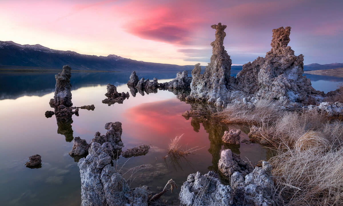
Mono is a saline lake at 6,383 feet elevation, believed to be over 750,000 years old. (The larger Mono Basin formed about 5 million years ago.) It lies due east of Yosemite, and if you know where to look, you can pick out Tioga Pass. This remnant of ancient inland sea is more than 13 miles long and 9 miles wide, with a surface area over 45,000 acres. Its average depth is around 57 feet with a maximum of around 150 feet (compare this to Pyramid Lake at 300, Lake Mead at 500, and Tahoe at a remarkable 1,600). The only “outlet” is evaporation. Key features are Negit and Paoha Island, and the lake’s iconic tufa towers, surreal Dali-esque/Gaudi-like limestone formations composed of calcium carbonate and then wind-eroded. Believe me, the wind here is a living thing.
Mark Twain, in his 1872 book “Roughing It,” described Mono as a “the loneliest place on earth.” I’ll grant him lonely and certainly eerie — but lifeless? No. Single-cell algae support brine shrimp and alkali flies, which in turn support massive migratory bird populations, including phalaropes and grebes, and a giant contingent of California gulls.
Beyond the lunar, volcanic, otherworldly intensity of the geology, Mono is the ancestral home of the Northern Paiute people known as the Kutzadika’a or Kucadikadi (“eaters of the brine fly larvae”), also known simply as the Mono Tribes. These master seasonal foraging-hunting people originally covered the area from the eastern Sierras south to Walker Lake. They remain known for the excellence of their finely coiled baskets. The story of Captain John, chief of the Mono Lake Paiute Kutzadika’a, is highly recommended.
Just 46 minutes due north of the lake is Bodie State Park, National Historic Landmark and one of the greatest full-scale ghost towns in the American West. “Preserved in a state of arrested decay” (I love that phrase), this gold mining camp became a boom burg with brothels, saloons, opium dens — the whole shootin’ match (literally). 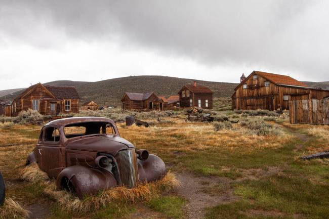
I strongly recommend enjoying the hospitality of the funky little town of Lee Vining and allowing yourself at least two days in the area, so that you can wander Bodie at your leisure and take in the lake from different vantage points at different times of day. Wind and temperature are vital factors. Late spring/early summer is ideal. Do not underestimate how quickly weather changes around great mountain ranges and major bodies of water.
The nearby June Lake loop incorporates four lakes for year-round sporting and sightseeing activities, with lodges and history to boot. It’s certainly worth anyone’s time. But the soul of this rain-shadow Sierra realm is Mono herself. To stroll around, hypnotized by the tufa towers, and then to glance up at the fearsomely gorgeous granite spine of Yosemite is to see what people of many colors down the years have thought they saw. This is a place of hallucination, ghosts and a persistent ecology of mystery … in any weather, any light. I envy anyone’s first glimpse.
IF YOU GO
Getting there: U.S. 95 through Beatty, to Nevada Highway 266 and California Route 168, through Bishop, California, approximately 5.5 hours. Mono Lake: monolake.org. Lee Vining accommodations: leevining.com. Bodie ghost town: parks.ca.gov/bodie
Notes on Camping
There was only one landscape for my first overnighter: Joshua Tree
By Dayvid Figler
Here’s the thing about camping — I don’t. Growing up in Las Vegas, where my dad worked as a card dealer with midweek days off, it was never a priority. Now and again we’d take a jaunt to Mount Charleston to see snow (“Oh! That’s what it feels like — not for me”) or a drive along the Red Rock loop (“I enjoy nature from the safety of the family Buick”), but there was certainly no camping gear involved. 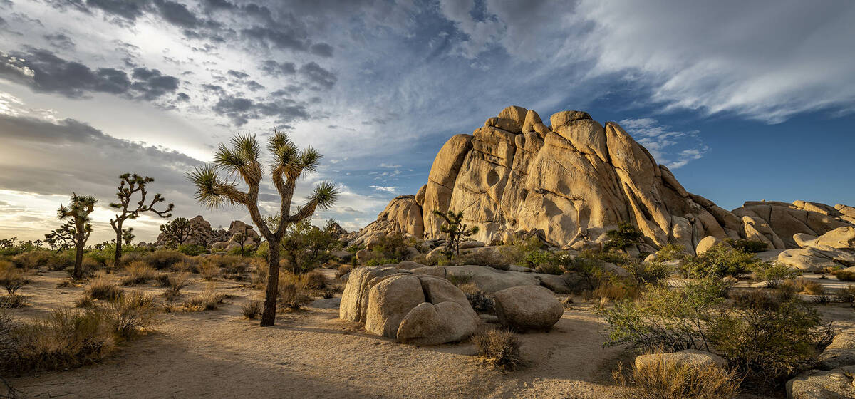
Then I fell in love with someone who loves camping. At first, it was easy to divert her suggestions, but as time and the relationship grew, there were only so many excuses I could offer. “Jews don’t camp” gave way to “I don’t camp” gave way to “OK, but let’s make it easy, and let’s also make it close to something civilized, in case I freak out.”
We picked Joshua Tree National Park for my first overnight camping experience. A scant three hours from Las Vegas and less than an hour from Palm Springs. I was promised the easiest of tasks (pound the tent stakes, inflate the air mattress) while she’d do all the hard work (erect the tent, make the food, defend us against wildlife).
The drive was easy. A charming journey through the Mojave National Preserve, starting with the Nipton exit from Interstate 15. If you find desert drives boring, this won’t disappoint; however, if you’re a fan of desert landscapes (including some Joshua trees even more impressive than those in the park) dotted with late-19th and early 20th century buildings like the Kelso train depot — sadly closed for the near future — there’s plenty to see in between stuff you usually see.
At the Twentynine Palms entrance, the closest to Las Vegas, we paid our fee and went to find a first-come, first-served campsite. Given the park’s almost 3 million visitors a year, these are typically hard to come by (there are also areas that allow reservations, so plan if you can), but because we went in late May/early June, with its harsh summer heat topping 100 degrees, the offerings were more plentiful. We found a nice site abutting a rock formation in the Hidden Valley Campground (44 campsites; $15 nightly fee) that gave us everything we needed, including a sliver of shade. A quick tarp on the ground, tent erected and Coleman stove out — and we were ready to go. 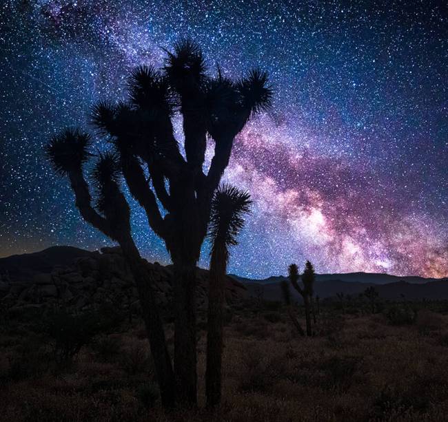
The park is a wonder of trails and pathways for walking and (my favorite) driving, and has all the fauna (spiky chollas!), rocks for climbing and multiple picnic areas you’d hope for. There’s an abundance of picturesque vantage points, like the Keys View, where you can check out the Salton Sea and a sweet, gentle 1-mile hike around Barker Dam. Nighttime brings pristine skies and little light pollution. The camping turned out to be easy, and despite the aridness (did I mention the heat?), the whole thing turned out to be glorious. We brought plenty of food (and requisite tons of water), including some choice steaks (drawing the attention of a persistent, hyper-aggressive pregnant squirrel) and camp-fired in the provided pit area in a very story-like manner. Once the squirrel was shooed (her job), we eased into the quiet and beauty of the park and all was right.
Not really sure what all the fuss was about or why it took her so long to convince me to come!
In sum, Joshua Tree National Park makes camping enjoyable for even the most-novice novice. Nearby is the cute town of Joshua Tree, with plenty of creature comforts like fast food and air-conditioning. Farther away but worth checking out is the famous Pappy & Harriet’s in Pioneertown, replete with rustic charm, mesquite barbecue and live music.
Every season provides different weather-specific features and challenges, so a little preparedness goes a long way — but don’t fear the leap. It’s guaranteed fun.
IF YOU GO
Getting there: I-15 through Barstow, about 4 hours; through Nipton, California, just over 3 hours; U.S. 95 through Needles, California, about 3.5 hours. Joshua Tree National Park: nps.gov/jotr. Salton Sea: parks.ca.gov/saltonsea. Pioneertown: visitcalifornia.com