Bitter Springs Trail a taste of adventure near Las Vegas
The rugged Bitter Springs Trail lies not far from the sprawl of urban Las Vegas, but seems a world away. Designated a scenic back country byway by Congress in 1989, the 30-mile route south of Valley of Fire State Park connects old mining roads, a mountain pass and desert washes between Interstate 15 and the Northshore Road in Lake Mead National Recreation Area. Allow at least two hours just to drive the route, more if you stop to explore.
To reach the trail, drive north on I-15 to the Valley of Fire exit, about 33 miles from Las Vegas. Follow the park road east about three miles to a point where the pavement swings to the left and a wide graded road points toward the dark Muddy Mountains ahead. Take the graded road, slowing down to find the smoothest course on the washboard surface, which sometimes is the road shoulder. About a mile along this road, note an old road crossing your route. This is part of the Old Spanish Trail, also called the Mormon Trail, followed by explorers, mountain men, traders and pioneers into Southern Nevada.
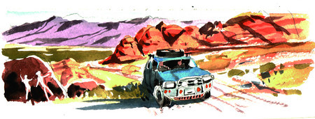
The challenging one-lane Bitter Springs Trail appeals to those who relish off-pavement exploration of little-known portions of Nevada. It attracts hikers, picnickers, back-country campers, horsemen, motorcyclists and ATV riders.
The first few miles as far as colorful Buffington Pockets, a region of vivid standstone akin to the Valley of Fire, may be driven in the family car. Beyond there, the road becomes a trail. It tops a summit and demands a high-clearance vehicle, preferably with four-wheel drive, as it descends into Hidden Valley by way of flood-prone arroyos. Although open all year, the route is best followed during the cooler months, and never on a rainy day because of flooding danger.
The graded road ends about eight miles from where you left the park road at the site of a rock quarry near the summit. Drive your passenger vehicle only as far as you feel comfortable. Find a place to park off the roadway and have a tailgate picnic in colorful surroundings.
The canyons invite investigation on foot. Watch for the natural potholes or water tanks that attract wildlife and at least one rock dam meant to catch and hold runoff from the cliffs. Evidence of old mines lies in plain view of the road, while remnants of ancient cultures in rock art panels or anthill-shaped agave roasting pits take some searching. Be wary around old diggings. Close to an old borax mine near the road, you’ll see deep cisterns and mine tunnel entrances. Mines are dangerous, so keep a sharp lookout for open holes and stay out of the diggings themselves.
If you continue beyond the end of the graded road, you will need a rugged vehicle. In the next 20 miles, there will be tumbled boulders to crawl over and deep sand and gravel to negotiate. In the wash near Bitter Springs, water runs on the surface, dampens the sand and encourages heavy vegetation. You will reach the Northshore Road about three miles south of the Echo Bay turnoff.
The Bureau of Land Management marks this byway with its distinctive triangular symbol atop brown metal posts, but never lavishly. Expect the signs at wide intervals. Places where you must choose a course will be marked, but can be confusing. At one point where you cross a deep wash, the byway takes an unexpected turn to the left, doubling back for a distance and seeming to head the wrong way. Follow it anyway. If you get off the main route, you will definitely need four-wheel drive.
For safety’s sake, never travel alone. Let a responsible person know where you are headed and when you expect to return. Carry a cell phone and a working flashlight. Pack picnic provisions, snacks and at least a gallon of water per person. Wear layered warm clothing and a hat. If you have room, throw a couple blankets or bedrolls in the vehicle.
Check your spare tire and jack and know how to change a tire. Veterans of such roads often carry a length of old carpet to put under the tires for traction. If you get stuck, you may deflate your tires about one-third for better traction, but reinflate them as soon as you reach facilities at Echo Bay on Lake Mead or Overton.
Margo Bartlett Pesek’s column appears on Sundays.