Beauty at every turn on Utah’s Highway 12
Southern Utah’s Highway 12 belongs to an exclusive group. Not only is it one of the country’s 150 Most Scenic National Byways, it also holds a place of honor among just 31 of those byways selected as All-American Roads because of an abundance of cultural, historical, geological and recreational attributes.
The 124-mile route is a destination in its own right. Drive it for the fun and challenges it presents, but allow enough time to sample some of the adventures found along the way.
Utah’s Highway 12 begins south of Panguitch on U.S. Highway 89 a few miles west of Bryce Canyon National Park. Producing calendar scenes around every curve, it threads its way east and north through canyons, pioneer-era towns and farmland, over eroded slick rock formations, past ancient ruins and climbs high forested plateaus to end at Torrey on Utah Route 24 nine miles from Capitol Reef National Park. It cuts in and out of Dixie National Forest and skirts much of the Grand Staircase-Escalante National Monument, passing three state parks, a Bureau of Land Management recreation area, campgrounds, viewpoints, trails, high-country back roads and some of the few roads into the nearly inaccessible Grand Staircase, part of the National Landscape Conservation System.
Watch for the first of several information centers just after you leave U.S. 89. Stay on paved Highway 12, an all-season route suitable for passenger vehicles driven safely. Start with a full fuel tank, a good spare and extra water. Take your time and enjoy the scenery. When you pull over, be sure your vehicle is off the travel surface. Side roads invite exploration, but many are suitable only for high-clearance or four-wheel-drive vehicles. GPS systems may be unreliable and cellphone reception spotty.
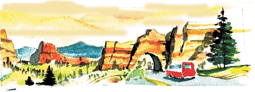
Open through October, the Red Canyon Visitor Center acquaints you with the first part of your drive through a spectacular forested region with vivid red sand, cliffs and eroded formations. Popular with hikers, campers, mountain bikers, horsemen and ATV riders, as well as winter sports enthusiasts, Dixie National Forest’s Red Canyon is a fitting prelude to the magnificent landscapes along Highway 12. The highway passes through short tunnels cut through some of the formations. A nine-mile paved bikeway parallels the route as it approaches the turnoff to Bryce Canyon National Park. Around a bend in the road three miles beyond the park turnoff is a parking area for the half-mile trail to Mossy Cave and Waterfall, part of Bryce Canyon.
The road drops into farm and ranch land in Bryce Valley through three pioneer-era villages. Find the handsome Cannonville Visitor Center for an introduction to the Grand Staircase-Escalante National Monument, the human history of the area and unique geological features such as those found in nearby Kodachrome Basin State Park, reached by a nine-mile paved road.
Highway 12 continues toward little Escalante, passing Escalante Petrified Forest State Park and adjacent Wide Hollow Reservoir, popular with campers, swimmers and fishermen. The Escalante Interagency Visitor Center is another good source of maps and information. Escalante annually celebrates art, literature, music and its history during a festival scheduled this year on Sept. 28 and 29.
The highway twists out of the valley into a landscape of stream-cut canyons and steep cliffs on its way to Boulder, once one of the most-isolated communities in the West. It passes close by the BLM’s Calf Creek Recreation Area with its campground, picnic area, wading pond and trail to a lovely waterfall. Then the road reaches the dramatic crossing of the Hogback, a narrow passage on a cliff top with deep canyons falling away on both sides and hundred-mile views. Little wonder the mail was delivered to Boulder on horseback for so long. Stop in Boulder at the Anasazi State Park and Museum, site of a pueblo of at least 100 rooms abandoned some 800 years ago.
The road climbs from Boulder north toward Torrey, paralleling Capitol Reef National Park to the east, passing access roads to alpine lakes and streams. It reaches 9,600 feet on Boulder Mountain before descending. Its ending point completes one of the most memorable scenic drives you’ll ever experience.
Margo Bartlett Pesek’s Trip of the Week column appears on Sundays.