Ancient visitors left mark on Grapevine Canyon

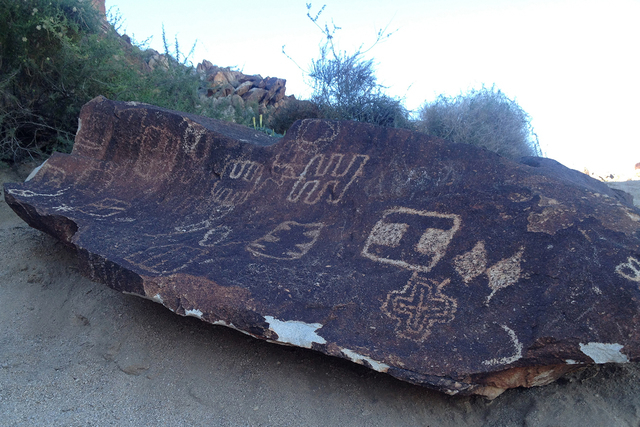
Intriguing Grapevine Canyon near Laughlin is home to a profusion of rock art left by native people starting about 1,000 years ago.
More than 250 panels of petroglyphs have been mapped in the desert canyon, which is listed on the National Register of Historic Places. Easily accessed by road and trail, Grapevine Canyon attracts enough attention that it is listed as the second-most popular place to visit for tourists to the resort area along the Colorado River in Nevada’s extreme southern tip.
To reach Grapevine Canyon, drive south on U.S. Highway 93/95. At Railroad Pass, turn south on U.S. 95. Drive 56 miles through Searchlight to the turnoff to Laughlin on state Route 163. About 15 miles south of Searchlight, you will pass one end of Christmas Tree Pass Road, a scenic loop route through the Newberry Mountains from the highway to Laughlin back to U.S. 95.
Route 163 heads east to thread its way about 20 miles through desert and mountains to Laughlin. About 13 miles from the U.S. 95 junction, watch for the turnoff on the left to Christmas Tree Pass Road. This graded road reveals beautiful desert and mountain scenery within Lake Mead National Recreation Area. It makes a nearly 15-mile loop between wilderness areas in a region sacred to native cultures living along the Colorado River. The area is popular for cool-season hiking, tailgate picnics, birding, photography and off-pavement exploring.
The first few miles of the loop road are suitable for passenger vehicles, but stay off the branching side roads. The road through the pass and most side roads are subject to flash flooding and may be rough. To complete the loop back to U.S. 95 or to explore side routes, it’s best to have a high-clearance or four-wheel-drive vehicle.
Christmas Tree Pass Road climbs into a forest of junipers and pinyons. Years ago, passersby decorated some trees with leftover Christmas ornaments and other shiny objects, such as beer cans. The National Park Service regularly removes the ornamentation, which it views as litter, but the tradition persists and the shiny debris reappears over time.
The road to Grapevine Canyon is safe for passenger vehicles. After leaving Route 163, head north about 2 miles to the Grapevine Canyon turnoff. A short spur takes visitors to an area with parking and restrooms. A trail runs west, skirting the edge of a gravelly wash for about a third of a mile to reach the mouth of the canyon, marked by huge boulders. In times of ample rainfall, a little stream emerges from the boulders and runs down the wash before disappearing into the gravel.
Wherever the native artists could find a suitable surface on these boulders, they inscribed the stone with their enigmatic symbols, producing one of the most extensive displays of ancient rock art in Nevada.
The meaning of many of these symbols is lost, but modern visitors readily recognize depictions of animals, such as bighorn sheep. Take plenty of pictures, but do not climb on the boulders or touch the petroglyphs, which are considered part of our national cultural heritage.
Hikers today walk in the footsteps of early visitors as they explore. Since there is always water in Grapevine Canyon, early hunters and gatherers would have utilized many of the plants found there, including the tangles of wild grapes that the place is named for. They would have hunted the many kinds of animals who were also attracted to the water, food and shelter found there. They, too, would have dallied in the shade and splashed in the pools.
The abundance of rock art in the canyon indicates its significance to the early visitors. It is located just south of Spirit Mountain, which figures in the creation stories of area natives. Its proximity to the sacred mountain would have given this canyon special importance.
Margo Bartlett Pesek’s Trip of the Week column appears on Sundays.